Outer Bank’s Day trip
For a new adventure, you should try an Outer Banks day trip to Cape Hatteras. The drive from Nags Head to Cape Hatteras along North Carolina’s Outer Banks is a great way to spend a day and see some stunning scenery and get a feel for the isolation of Cape Hatteras from the mainland. We started our trip on Roanoke Island with a cup of coffee at Front Porch Coffee. With caffeine in my system, we headed for NC Hwy 12.
The name Virginia Dare vaguely meant something to me as I saw the Virginia Dare Bridge headed back east towards Nags Head from Roanoke Island. I found a lot of interesting information looking further into the history of Virginia Dare. You can find a great summary here at the Outer Banks website. I’d also recommend another day trip to the Fort Raleigh National Historic Site on the north side of Roanoke Island.
NC Route 12 South
As you come to the split in the road at US64/US158, head south on NC Hwy 12, the Cape Hatteras National Park Road. This road continues south all the way to Cape Hatteras and beyond. Note your mileage as you start on the Park Road. Along the way, you’ll pass through a variety of coastal terrain and environments and have plenty of interesting stopping opportunities. Right now, I think the Herbert Bonner Bridge makes a great first point of interest.
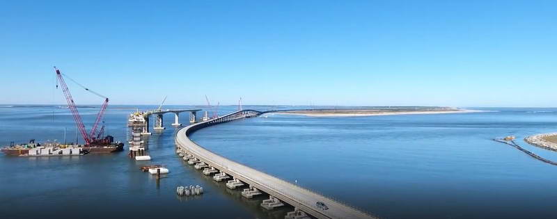
Herbert Bonner Bridge
The Herbert Bonner Bridge, about 8½ miles down the road, is currently being reconstructed. Actually, a new bridge is being built parallel and to the west of the current bridge. This is a great teaching opportunity for younger kids as they can see the many different phases of construction.

Even as an adult, I found the effort amazing. The one downside is that you only get a chance to really see the work when you’re stopped in traffic (single line of alternating traffic across the approximate 2.8-mile span). The construction should be complete in November 2018 followed by the demolition of the existing bridge. This $246 million effort is a truly amazing site when you take the time to digest the scope, complexity, and scale of the work underway.
At the end of the bridge you’re on Pea Island; don’t ask me where the name came from, I have no idea. As you continue south on NC 12 you pass miles of sand dunes to the east which block the view of the ocean, but on their own they’re amazing. As you get to the towns of Waves and Salvo, you’re close to a great place to stop and stretch your legs.
Clarks Bay
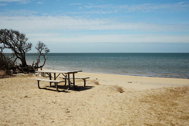 About 29 miles down the Park Road and just outside the town of Salvo watch for a sign for the Salvo Day Use Area off to your right side. While not very glamorous, all the way at the north end you’ll find restrooms and not too far away, some weather-beaten picnic tables at a beach. We found this a great place to stop, stretch our legs and explore the sand along Clarks Bay. After you’ve got your energy back up, it’s time for the day trip to continue as you explore the sand dunes.
Beach Access Roads
As you continue south on the Park Road there are beach access roads every several miles that give you a chance to explore the sand dunes and get a view of the Atlantic Ocean. The first one is about a mile past the Salvo Day Use Area on the left – the ocean side. There’s a parking area with a boardwalk to the dunes, or you can chance a venture down the side road. A word of caution – heed the warning signs as the road turned suddenly into tire sucking sand…not recommended unless you have 4 wheel drive.
The walk to the beach is less than 800 feet and you’ll hear the roar of the waves as you get nearer. The day we were there, the wind was from the east. Up until we reached the crest of the dunes, it was not too windy and it was warm. As we walked through a gap in the dunes the intensity of the wind quickly increased and our experience transitioned into a wild and beautiful combination of wind, sand, and waves. The magnitude of difference from the relatively placid Clarks Bay on the west side to the Atlantic Ocen is stunning. You have to experience it.
Over the next 10 miles, there are several more access roads, each with different experiences. At one point the width of the island is less than 800 feet and along the entire road, sane is everywhere. There’s also a stretch of protected areas where you can’t enter; just watch for the signs.
Lighthouse – Mile 47
The Cape Hatteras Lighthouse is near the end of the road at… you guessed it – Cape Hatteras. This is a small community with rental property and camping out at the edge of the ocean and miles from the continental United States. The isolation is sobering when you consider it.
The Cape Hatteras Light Station, as it’s officially known, is part of the Cape Hatteras National Seashore. There are ample parking spots and a nice visitor’s center. The station was manned from 1803 until 1935 and served to warn ships of the dangerous navigational challenges of the area. It also served as a reference point for navigation. The lightkeepers were responsible for the operation of the light which included raising large weights every 2-3 hours which provided the mechanical power to precisely rotate the light. There’s an array of stones set outside the visitor’s center, the carved names of the lightkeepers recognize their service.
More to come…