It was our wedding anniversary when we arrived in Glacier National Park. One thing that everyone needs to know about Glacier National Park is the cell service. It is somewhere between non-existent and abysmal. For most of the park, expect to see No Service on your mobile device. As far as WiFi goes, forget about it as well. No place has WiFi (or WeeFee as one local pronounced it). After two days in Grand Teton National Park with no cell and marginal WiFi, we were prepared for several more days cut off from technology.
Breakfast
On our first morning, I arose early and headed out in search of coffee and breakfast. The line for coffee was incredibly long at one spot- only one spot. No place had breakfast. I gave Julie the news and we headed out. In West Glacier, just outside the park, we grabbed a couple of breakfast burritos that were amazing. Potatoes, green peppers and onions, cheese… and of course scrambled eggs. Great coffee to boot!
Munching on the breakfast burritos, we drove back into the park and onto Going-to-the-Sun Road. The weather was overcast and about 50 as we started. We made a few stops along the lake as we headed north. Every time we got out of the car we were greeted with the fresh smell of pine.

Initially, our intent was to reach the continental divide at Logan Pass – 32 miles at an elevation of 6646′. Going-to-the-Sun Road starts at the south end of Lake McDonald, slowly gaining elevation along the east side of Lake McDonald.
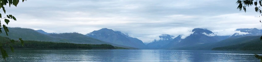
Along the lake
McDonald Falls on Avalanche Creek was a nice first stop for us. Quiet and scenic, we relaxed and shot a couple of photos. From that point, the road pretty much follows McDonald Creek, getting steeper after the Avalanche Creek picnic area.

After we passed over Avalanche. Creek, we started to get some rain, and wisps of clouds started drifting lower. This was not great for sightseeing, but we were in explorer mode. Before approaching Logan Pass, we had to navigate ‘the loop,’ a hairpin switch-back with a perilously sharp drop to the left as you approach.
Weather closing in
By this time, we couldn’t see the tops of the mountains as they were shrouded in a heavy layer of clouds. Below that, the winds and rain had picked up and those wisps of cloud were now denser, and rapid-moving clouds as they pushed up the west side of the peaks.
From ‘the loop’, and until we passed the ‘weeping wall’, Julie often chose to ignore the view because of the steep drop outside her window, down to the valley floor far below. I stopped several times and tried to capture the clouds and the terrain, but this wasn’t great photography weather.

After the clouds closed in, the temperature dropped, and the rain really picked up. Suddenly we found ourselves at Logan Pass. The temperature was near 40, and the wind was driving a steady rain. Because of COVID, the indoor section of the visitor center at Logan Pass was closed. Also, because of the weather, no one was hanging around outside to ask any questions. 90% of the ‘visitors’ were simply making a mad dash to the restrooms and then back to their vehicles.
Heading East
Surprisingly, as we headed further east from Logan Pass, the clouds and rain diminished. It was still sprinkling, and cloudy when we reached the Jackson Glacier Overlook. The receded Jackson and Blackfoot glaciers, visible from that point, were a disappointment. (Global warming is causing glaciers to retreat)
Our next stop was at Sun Point Nature Trail. After a short walk down towards Saint Mary Lake, we came out on a promontory with an incredible view south, across the lake. We could clearly see a large hanging valley across from us and peaks to the east and west. It was beautiful. (It was also cold with a cutting wind)

We continued east on the highway, the views were magnificent. We exited the park at the Saint Mary Visitor Center, an considerably less busy location compared to West Glacier. The Saint Mary entrance is located roughly halfway between the southeast corner of the park and the northeast corner at the Canadian border. The 29 miles between the Saint Mary entrance, and East Glacier Park, at the southeast corner of the park, was an interesting drive.
Outside the Park
Warnings to ‘consider alternative routes’ and ‘intermittent pavement’ are appropriate. The 8′ reflector-tipped markers off the sides of the road are stark reminders that this area gets a healthy allocation of snow in the winter. (Really? Do you need markers 8′ off the ground?!?) I should also mention that for 86 miles between Saint Mary and West Glacier we saw only a single gas station in East Glacier Park.
All in all, this trip took us five hours, less one 30 minute nap somewhere in the Flathead National Forest where we pulled off Hwy 2. Tomorrow the weather is supposed to be better, except for the snow. Hopefully, we can provide a better narrative of Glacier National Park.
Welcome to northern Montana in August.