The Rest of Alaska I
 We were back on land in Alaska. Now it was time for our adventure after the cruise! But first, let’s get off the ship.
Near the end of August, our Holland America Alaska cruise ship dropped us in Seward, Alaska where we boarded a bus for Denali National Park. I have to say that the level of planning, coordination and communication to get 2000 passengers off a ship and on their way to cities, trains, airports, buses and who knows what else must be daunting.
The ship leveraged published schedules, public meetings, and information packets and luggage tags delivered to our room. Granted, they have years of experience doing this, but to pull that off was impressive for us. In a few short hours, everyone was off the ship and on their way.
Seward is situated on Alaska’s southern coast, on Resurrection Bay, a fjord of the Gulf of Alaska. This puts it approximately 120 miles by road from Alaska’s largest city, Anchorage, and nearly 1,300 miles from the closest point in the contiguous United States at Cape Flattery, Washington.
I looked at a map and thought, okay, Seward to Denali. Well, it doesn’t look that far… Then I looked at the scale on the map. Whoa! Alaska is huge. We had a full day drive in a bus, a comfortable bus, but still, a full day on a bus. On the other hand, it was a beautiful trip.
Leaving the seaport of Seward early in the morning, the sun was still struggling up into the sky and I hadn’t had enough coffee. The first portion of the trip took us through the mountains of the Kenai Peninsula, but I have to admit that I slept for much of that. By the time we’d passed Anchorage, I was awake and we could see the significant mountains ahead of us, pale blue smudges on the horizon. As we continued north towards Denali, the mountains shrunk in distance and grew in size.
 Our first rest stop was outside Wasilla, Alaska. I once heard that that from here, on a clear day, you can see Russia from your front porch. I guess it was a bit too cloudy that day…. We did, however, see the Iditarod Museum in Wasilla. There was a dogsled demonstration, albeit on wheels because, well, it was summer and no snow. A walk through the museum dedicated to Alaska’s famous annual dogsled race seemed a requirement so in we went. There’s a lot of memorabilia from past races and lots of color here. This is a spot that that I’d highly recommend you stop and spend 30-45 minutes.

The trip continued north on Hwy 1, through the broad Susitna Valley south of the Alaska Range. Both to the east and west we could see the foothills, but being from the lower 48, we called them mountains. A couple of times we saw Denali peek out from behind the clouds and the ‘foothills’ designation started to make sense. This is one of the reasons we selected the Holland America Alaska cruies, because the land protion takes us right inside of the beautiful State of Alasks.
It was late in the afternoon when we got to Holland America’s comfortable resort, just outside the park. After some exploring and dinner, we settled in there for the night. Tomorrow was a full day and we were reagy to continue the on-shore adventure after the cruise.
Related Posts
Ketchikan Zip-Lining
Ketchikan Zip-Lining

Ketchikan, Alaska
Ketchikan, Alaska was our first stop on our Alaska cruise and we’d planned on spending part of the visit zip-lining across the canopy of a rain forest. Well, we got our wish. Joined by four other hardy travelers, we headed off the ship in a pouring rain with temperatures in the low 50s. Our guides welcomed us, and let us know that this was a typical day in Ketchikan as they have over 300 rainy days a year. (Good to know…)
 After a 15 minute bus ride, we arrived at the Kawanti zipline site, the guides quickly whisked the six of us up the hill in a sturdy 4×4 truck. Oh, I should mention that the ‘covered truck’ had a top, but no sides? Little did we know that the dampness was simply foreshadowing for what was to come.
Buckle Up!
In a large, roughhewn wooden building, our guides briefed us and introduced us to our equipment. The harnesses and gear were in good condition and the instructors answered all our questions. Julie and I wore our rain coats, but rain jackets were available. After a final equipment check we were outside and on to the first zip.
Julie and I have zip-lined several times and thoroughly enjoy it. We’d zipped in the rain previously, but that was in Hawaii and the temperature was close to 80. Today was going to be different. By now the temperature had warmed to maybe 55, but the wind gusts had started to pick up. After the first, introductory line, we were ready to start on the “real lines”.
The towers are platforms anchored to large trees, and by necessity, it’s a long way to the ground. The views were awesome and the forest completely quiet… except for the wind surging through the trees and the rain. It was beautiful as we could see through gaps in the trees out to the channel to Ketchikan.
 The canopy of the trees serve as giant umbrellas of a sort, sheltering us from the heaviest rain. The first line was about 750’ long. Once you leave the platform it takes just a moment to steady and orient yourself, then you can enjoy the view and the ride across the top of these forest of these giant trees. Then the guide gives the ‘brake, brake, brake’ signal and you find yourself on a platform near the top of a different tree. However, by the time I reached the other end of the first line, the rain had managed to soak my pants. On the other hand, it was fantastic fun.
Enjoying the Weather
By the fourth tower the rain was no longer falling down on us. The wind had picked up and was now blowing the rain nearly horizontally. That negated the protective effect of the canopy, but made the experience more memorable as the trees started to noticeably sway and we could clearly see the sheets of rain being carried across the valley by the challenging winds. It was about here that I realized the rain had soaked through my pants and my underwear had now joined in experiencing the natural wonders of Alaska.

The last three zip lines were just as exciting as the first four. We all joked about the wind and rain, but no one was really complaining. Most in our group were first time zip-liners and they were caught up in the challenge and excitement. One brave woman was in her late 70s. Like everyplace else where we’d zipped, it’s just that first step off the platform that you have to overcome, then it’s all fun and excitement.
Back on the Ground
At the last landing platform we rappelled down, one at a time. One of our guides, Heidi, came down last… head first. A short walk took us to another equipment building where we climbed out of our gear. We were a glad to be in out of the rain, but the discussions centered in the fun and the beauty of the forest. Everyone was glad we hadn’t let the weather discourage us.
Related Posts
The Rest of Alaska I
The Rest of Alaska II[Pending]
Trip to Wanaka
 The last day of November found us leaving Franz Josef for Wanaka. This is a beautiful trip, leaving the lush landscape at the base of the Franz Josef Glacier and heading along the coast until turning inland at Haast. As we headed south, out of the town, we had one last glimpse of the immense glacier towering over the town.
After a few short miles we were again driving along the coast with the Tasman Sea to our right and mountains towering to our left. Before heading inland, we came across this plaque commemorating the opening of the Haast-Wanaka road in 1965.  Before that, you had to drive north and across Arthur’s Pass to get from the coast to Wanaka. This highway cut the drive from over 1,000 kilometers to less than 150!
Roaring Billy Falls
Just in from the coast we came to a bridge outside Haast township. Measuring 2,418 ft, it’s the longest one-lane road bridge in New Zealand, and the 7th longest New Zealand bridge overall. From Haast we started our climb up into the South Island’s Alps on our way to Wanaka on our old friend State Highway 6. Highway 6 follows virtually the complete length of the Haast River, sometimes at a distance and other times right along side the often roaring river.
In a wooded area, maybe 15 miles from Haast, we pulled into a small parking area. There’s a well maintained trail through some woods that suddenly opens up to the Haast River. The valley floor is wide, flat and covered with rounded stones of all sizes. We had fun exploring the riverbed and Roring Billy Falls. Then it was back to the car and we were on to Fantail Falls.
Fantail Falls
There’s a nice parking area at Fantail Falls, and the falls are just an easy five minute walk away. The segmented fan shape of the falls give it the obvious name. What made this place interesting to us were the stacked rocks. The riverbed is covered with millions of relatively flat, rounded rocks that have been work smooth by the water. Visitors have taken to making small stacks of the stones, and there are lots of stacks. One fallen tree is absolutely covered with various stacks from one end to the other.
 |  |  |

Crystal Clear Water
Blue Pools and Devil’s Bath was our last stop along the Haast river. While the walk from the road was a bit longer, it was well maintained path and took us through an interesting section of forest. As we came out of the woods we were first struck by the clarity of the water. The water was clear enough to see the fish when looking down from the high stone banks that are 20-30 feet above the surface. The colors of the water were astounding as well with various shades of blue and green. The trail along the river includes a couple of small suspension bridges that gave us a beautiful view up and down the river and provided access to additional trails. The hike was beautiful and presented lots of photo opportunities.
Approaching Wanaka
The last two stops before Wanaka were on either side of “The Neck”; a narrow, passable section between Lake Wanaka and Lake Hawea. It seems like every five miles we came across another incredible view on the South Island and these stops were no different. Again, we stopped and marveled at the view and then took plenty of pictures. At one point wee could clearly see a shower coming across the mountains, miles away.
 |  |
That trip from Frans Josef to Wanaka took us from the foot of a glacier, along the ocean shore and then up and through the ruggedly beautiful mountains and finally down to another beautiful town. Set high in the ‘Southern Alps’, Wanaka was beautiful. Getting to Wanaka has to be one of the most interesting and varied drives we’ve ever taken, and it was all packed into one day.
South Island- Franz Josef Glacier
Franz Josef
Continuing our trek south on Hwy 6, we came to Franz Josef, a small village just a few kilometers from the impressive Franz Josef Glacier. The town is definitely focused on tourism, so we found plenty of shops and restaurants to serve every taste. We met up with John and Carol Brewer just outside of town. With no cell, text or email, I still can’t figure out how we managed to coordinate as well as we did.
In any event, it was late in the afternoon when we got there, so we chose to check into our rooms first. We stayed just north of town at the Westwood Lodge, a cross between a bed and breakfast and a hotel. Then we were off to explore in the town.

Everything is located right on Hwy 6 (Franz Josef Highway) or 1 block east on Cron Street. There are plenty of friendly and well staffed outfitters and tour operators, all located within a block or two. (Of course, the town is only three blocks long…) The Franz Josef Glacier dominates the skyline to the south of the town. Almost dead ahead, looking south from the town you get a great view of the Franz Josef Glacier.
 We had dinner in a local place on Cron Street – Alice May’s. Then, since it was still early, we took a short walk around the town to get our bearings for the next morning. With Julie driving and John navigating, we headed back to the Westwood Lodge. I should mention that there was a bit of confusion on the return trip to our lodging. The ‘kids in the front seat’ couldn’t agree on the best place to park, or even the best route into the parking lot. Fortunately, Carol and I figured it out from the back seat. Kids!
Taking Flight
The next morning we headed back into the town. We had a 10 AM helicopter ride taking us over the Fox Glacier and then landing on the Franz Josef Glacier. The glacier descends into the lush native rain forest of Westland’s National Park near the village of Franz Josef. This descent occurs from a height of nearly 10,000 to 750 feet above sea level over just 11 km. This makes it one of the steepest glaciers in the country. We were landing near the top, and we were all pumped!

Carol and John were new to helicopters and Carol had plenty of questions during the safety brief. Once we were briefed, we headed across the road to the airfield and met our pilot. As he started the engine, and went through his checks, we had more safety briefs- approaching the aircraft, hand signals, emergency procedures, loading order, etc., and then we loaded into the helicopter.
We were all smiles as we lifted off the ground, turned and headed south. With nothing but mountains ahead of us, the helicopter climbed and climbed over a series of ridges. The higher we went the better the view. Finally, crossing the last ridge we started a left turn and headed for Fox Glacier. Crossing the narrow ice flow we then flew up and across the Fox Glacier’s snow field and towards Franz Josef Glacier.
We didn’t realize how high we were or how large the glacier’s snow field was until the pilot pointed to a speck on the ground. As we got closer that little speck resolved into a helicopter and a hut on the ground. Suddenly the scale of what we were looking at changed! These glaciers are huge! Continuing to climb up the glacier we landed on a spot close to the top of the mountain, on the eastern edge of the snow field feeding the glacier. The elevation was a bit over 9800 feet.
This was our first walk on top of a glacier, so it took a few minutes to figure out what to do. Initially, we all just tromped through the icy snow and looked around at the ice and mountains in awe. Then came the snow angels and putting snow down the backs of jackets. Being up there at the top of a glacier was fun, exciting and awe inspiring. We had an absolutely fantastic time. But, after about 40 minutes it was time to head back down.
 |  |  |
 |  |  |
Climbing back into the helicopter was interesting as we realized that the skids had sunk into the snow on landing. Once buckled in and everything checked, we lifted off and swung to follow the glacier down the mountain. As we picked up speed we slowly climbed to a few hundred feet over the ice and followed the curving valley down.

The view was amazing. As the ice became more and more fractured, we could see the blue ice under the covering snow. The colors and texture was impressive. Soon we passed over the face of the glacier then climbed out of the valley before curving west of the village. The pilot then made a long gentle turn to bring us into the airfield from the west.
We all agreed that the trip was worth it. While the flight itself was an adventure, it doesn’t compare to the stunning visual display of nature we experienced. But the opportunity to walk on the snow above the glacier was an experience we’ll not soon forget. If you make it to Franz Josef, make sure you find a way to get to the top of the glacier!
After lunch the four of us drove up the south side of the Waiho River to the Alex Knob Trail and the Franz Josef Glacier Carpark. From there he headed out on foot with the goal of hiking to the face of the glacier. Walking through a rain forest trail to the river we noticed that Mother Nature wasn’t going to cooperate with us. When a light rain started, John and Carol pulled out their rain ponchos while Julie and I just stared at each other. Over the next 20 minutes the rain became harder and colder, so Julie and I turned back. The Brewers plowed ahead to the face. Julie and I dried off at the car as best we could and waited for our adventurous companions to return.
New Zealand – Coast
 We left Nelson and headed south for Hwy 6 along the Buller River. The river, and the highway, run generally west through the Buller River Gorge. Originally a gold rush town, Murchison was almost completely destroyed by a huge earthquake in 1929, and we were going to explore the heart of that earthquake. We first stopped at the Buller River Gorge Swing-bridge.
The Buller River Gorge Swing-bridge sits adjacent to the fault line from that 1929 earthquake, but getting there was a trip in and of itself. Hwy 6 provides a spectacular experience as you drive along the Buller River gorge; on one side you have a view into the gorge and the river itself. On the other side, the cliffs rise above you to the north providing spectacular mountain views. Because you drive on the left in New Zealand, I had a view of the drop to the river out my window while Julie marveled at the rising cliffs to our right. It was a spectacular view regardless (or, irregardless) of where you sat. About 10 miles west of Murchison we stopped, built up our courage and made our way across the Buller River Gorge Swing-bridge. While sturdy, I’d hardly call it a bridge, but it sure did swing.
 On the other side we explored some old buildings and walked for quite a distance through the crevice left by the 1929 earthquake. The crevice resulted from 4.5m (14.8 ft) of vertical and 2.5m (8.2 ft) of lateral movement that continued right across the water of the Buller River. It was interesting walking along the fault. We continued to the river and could see the offset on the wall of the gorge across the river as well. Then it was time to cross that ‘bridge’ again- we all successfully crossed with no issue. That was our excitement for the day.
Continuing west, just after Hwy 6 turns to head south along the coast we took Wilson’s Lead Rd. and headed for the Seal Colony at Tauranga Bay. That was the right choice as we had a chance to see plenty of seals and an incredibly rough coastline. It’s no wonder the point north of here is called Cape Foulwind. The blowing wind and relentless waves were both assaulting the rocky coast with wild abandon.
 We spent our first night on the South Island’s west coast at the out of the way Birds Ferry Lodge. It’s a beautiful bed and breakfast that’s a bit off the beaten path but definitely worth the trip.
Alison and André were our hosts and made us feel right at home. Alison prepared a fantastic dinner, after which we relaxed on the deck with a great view of the mountains to the east and a colorful sunset to the west. André provided us with plenty of advice and several recommendations on how to make our adventures on the South Island’s west coast even more interesting. He also noted that fuel was an important consideration as there aren’t a lot of fuel stations along the west coast, so top off when you can.
 Since we had seen a sign that it was 90 km to the next gas station I was up early the next day and headed back to Westport (which we had bypassed the previous day) for gas. The largest city on the west coast, Westport tops out with a population of about 5,000. There were two gas stations in town! I fueled up and headed back to Birds Ferry for breakfast. Our first stop for the day was one of André’s recommendation – Truman Track.
 Truman Track looks uninspiring from the road – nothing but a path heading into the woods. The walk takes you through the small forest of native trees that opens into a field of flax bushes. We heard more birds than we saw. The track “officially ends” at a lookout point where we had an expansive view of the Tasman Sea and Truman Beach. We continued on to the right, down to Truman Beach via a small staircase.
The crescent shaped beach backs up to limestone cliffs that have been undercut and large rock formations carved by the wind and water. This place is beautiful to explore and we spent nearly 45 minutes under the overhangs and climbing and exploring the rock formations. If you make it to the South Island, this should be a ‘must stop’ on your journey.
 Pancake Rock is just a few miles down the road, but sharply contrasts with Truman Track. You can read about the geology of how these formations developed at the New Zealand Pancake Rock website. They resemble stacks of pancakes… but huge stacks… made of limestone. The area has a nice track for walking and there are several blowholes scattered among the rocks.
We weren’t there at high tide, however the blowholes and the deep chambers were still quite active. If you can, time your visit to coincide with high tide. You can get the tide schedule at this link for the Westport Tide Schedule.
We visited the end of November, and there weren’t overwhelming crowds, but this is a popular stop. Looking south from viewing area over the cliffs we could see the snow covered mountains of the far off on the distant horizon. The paths are well maintained and the blowholes are active, making this is a great place if you’re traveling with kids. (Just keep an eye on any little ones…)
Further south, we stopped in Hokitika for a late lunch and a chance to explore this interesting town. Then it was time to hit the road again since we had nearly two more hours of driving to get to our next stop. In this case, our next stop was the Franz Josef Glacier, located in… Franz Josef!
Related blogs
New Zealand’s South Island – Nelson
New Zealand’s North Island and Auckland
New Zealand – South Island
 The South island of New Zealand has a lot to offer. We struggled deciding what to see in the two weeks we allocated to explore this place. There are towering mountains that surround peaceful sounds in the south and hug the rugged western coastline. Those were our targets – we’d start in the north and head west to explore the coast and then inland to explore the mountains and the natural beauty of the fjords in the southwest.
Nelson was our first destination. While the Nelson-Tasman region has the most annual sunshine of the entire country, we arrived in the rain. The Nelson-Tasman region has long been a magnet for creative people; as a result, we found plenty of galleries and wineries to explore.
Able Tasman Charters hosted us on our first adventure, and it was awesome! They met us on the beach at Stephens Bay. We rolled up our pants, climbed into the waiting zodiac, and took the short ride out to the waiting boat to start our day. Their website says it all… “If you’ve only got one day to enjoy the Abel Tasman, why choose what you want to do? Take ‘The Best Abel Tasman Day Trip’ with Abel Tasman Charters and cruise, swim, kayak, bush walk along some of the Coastal Track (one of New Zealand’s Great Walks), experience the coastline, see the wildlife, learn about the environment and ecology of the area.”
 We saw seals, birds, dolphins and beautiful islands. Split Apple Rock was one of the first and most interesting sites. The crew, Captain Rob and his son, Angus, were patient and helpful at getting us in the best position for photos throughout the trip. With only six passengers, we had nearly unlimited flexibility in going where we wanted and staying as long as we wanted. We headed up the coast, stopping briefly off Adele Island, a bird sanctuary before continuing on. Along the way we relaxed and watched the seals in the water. Before breaking for lunch, Julie and I took our sea kayak and paddled into Bark Bay with John and Carol Brewer. It was a nice spot, so Julie and I hauled the kayak up onto a beach and hiked around the area for a bit before heading back for lunch on the boat.
The seal colony at Tonga Island was where we turned back south, but not before drifting offshore to watch the seals sunning themselves on the rocks.  Along the way back we took the opportunity to walk through one of the most diverse coastal bush tracks on the Pitt Head Nature Loop. The hike was fun, but the views were amazing!
After the hike, Captain Rod was waiting for us on the beach to transfer us back to the catamaran. We continued south, now retracing our course from the morning’s cruise. Before we knew it, we were back at Stephens Bay off-loading onto the beach. We’d had a great time exploring the waters and the coast of the Able Tasman National Park.
If you’re looking for a great view of the Able Tasman National Park from the water, or if you’re just looking to have a fantastic day on a boat, I highly recommend Able Tasman Charters.
Related blogs
New Zealand’s South Island – West Coast
New Zealand’s North Island and Auckland
Sydney, Australia
New Zealand – North Island
We arrived in Auckland, New Zealand on the evening of Tuesday, November 20th. After a month in Australia and Fiji, we were somewhat used to driving on the ‘wrong’ side of the road. As a result, we had a chance to relax and enjoy the ride into the city. Our hotel was on the water in the revitalized wharves area so as soon as we were checked in we headed out exploring.
Originally the Viaduct Lighter Basin was a run-down commercial fishing harbor. Redeveloped and renamed Viaduct Harbour, this part of the city is very alive with apartments, shops and plenty of restaurants. Even on a Tuesday night, many were full with waiting lists for dinner. It was here that we discovered the “unburger”, and it was delicious. In amongst the other restaurants was Fokker Bros., a casual upscale burger place. They have a nice selection of burgers – The Fokker Cheese, The Buffalo Chicken, The Bacon Mac ‘N’ Cheese, and the Kiwi Black, just to name a few. The unburger replaces the bun with thick sections of Iceberg Lettuce. Wow, that was great. You don’t fill up on the bun and you get a great burger!

Besides the food, we found time to visit the Maritime Museum in Auckland. Inside the museum is a full-size replica of boats used in the discovery of the islands from Polynesia over 1,000 years ago. At the other end of the spectrum is a static display of the New Zealand yacht from the 1988 America Cup races. It’s huge, requiring a crew of 40+; this monster dominates the plaza adjacent to the museum’s entrance.
After a few days in Auckland, we headed south; our first stop was to visit some glowworm caves. The site we selected was Ruakuri Cave. Legend has it that Ruakuri Cave was first discovered 400-500 years ago by young Maori hunting for birds. He was attacked by wild dogs just outside the original cave entrance – Ruakuri loosely translates into Cave of Dogs. You enter the cave and descend down a long, circular set of stairs.
During the tour, we received an interesting education about the glowworms, their lifecycle and how/why they glow. Then the lights were turned off and we saw the blue glow of thousands of individual worms. It was amazing. Another interesting experience was listening to the underground river and waterfalls in the cave. Sometimes a distant rumble, it became a thundering roar as we got closer to the falls. Ruakuri Cave was an interesting and worthwhile adventure for us.
Our next adventure was getting to our next destination, Rotorua. Looking at the map it seemed simple enough. Head east then northeast on Hwy 30 all the way to Rotorua… I figured 2½ hours tops. Well, first off, Hwy 30 is a two-lane road for the most part, and it goes through plenty of towns, so after about four hours, we knew our original estimate of a bit off. Then we got to the junction with Hwy 5, just miles outside of Rotorua – there was a nice highway worker pulling a barricade across the road. A washout had the road blocked.
 We couldn’t find any easy alternate route, but the highway person claimed there was an ‘easy bypass’ that was ‘just down the road’. With that, we were off. Before we knew it, we were traveling across increasingly less improved roads, then gravel roads and then dirt roads. When the dirt roads started getting dicey we also realized that we hadn’t seen any other cars or people for some time… and it was starting to get dark. Even the cows and sheep looked at us in interest as if they were saying, “What the heck are those people doing way the heck out here?”

Obviously, we made it out at some point, but we considered trying to head back the way we’d come several times. Because I was unsure if I could find my way back, and I was concerned about running into New Zealand hillbillies (cue the New Zealand banjo music…), we continued forward.
 Two things that stood out from our time in Rotorua were a visit to a cultural center and a ride in a float plane over the volcanic region around Rotorua. From the plane, we could clearly see a rift that went across an old volcano, through a lake and a river. We were also able to plainly see other impacts of recent seismic events. It was an enlightening and beautiful flight, and taking off and landing on a lake made the flight all that more interesting.
We had a tour and traditional dinner at the cultural center. The Fairy Spring was very interesting. The natural spring here produces a huge amount of water daily. At one spot the water wells up in a pool that has blue-grey sand on the bottom. Eddies and currents from the upwelling of water made it appear to be boiling water – it was actually very cool. We also had a chance to observe several Kiwi birds that evening. They’re actually nocturnal, flightless birds, so spying them on the ground in the dark was difficult, but we thought it was something special.
Related blogs
New Zealand’s South Island – Nelson
New Zealand’s South Island – West Coast
West Texas

Cactus
Did you ever wonder if the pointy end of a cactus plant was actually pointy… or sharp?

Julie, Sharon and I had left Carlsbad Caverns National Park earlier in the day and were on our way to Las Cruses, New Mexico. Idling down the highway at… (well the speed limit was 75 MPH…), anyway there is a beautiful view of the Guadalupe Mountains north of the highway. We found a place that had a great view and pulled over for a photo shoot.
What made the scene so appealing to the passengers was the scrubby vegetation and the barbed wire fence in the foreground of the mountains. This was an authentic southwest setting! We got some great photos.
So, about the cactus… I don’t want to mention who went first, but ‘someone’ mentioned that the cactus looked sharp, and then proceeded to touch the end of the spiny leaf… ‘Ouch!!’ It turns our that the pointy leaf is sharp. After some discussion about how hard you had to touch it… or how softly, the other someone proceeded to touch the end of the spiny leaf… ‘Ouch!!’ Seeing a pattern developing, I avoided the cactus.
 |  |  |

Sydney
 Sydney is a city built for walking, exploring, and photography.
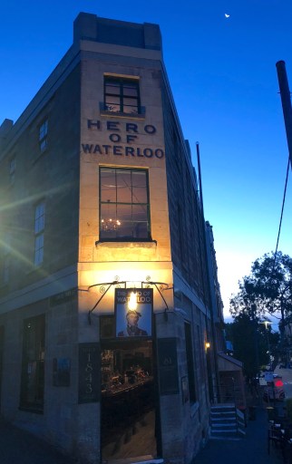
We started our exploration of the city on a walk exploring the oldest pubs in Sydney. It turns out that there are four or five pubs each claiming the title as the oldest. Dave’s Pub Tours gave us a nice overview of these historic pubs and some of the city’s history as well. Hart’s Pub was our first stop where we met ‘Dave’. The Hero of Waterloo (photo on the right), Lord Nelson’s Brewery and Hotel, and the Australian Hotel were the other candidates we visited.
Each venue had something unique about it and there were interesting narratives on the history at each stop. Evidently, there was some trade in shanghaied sailors in Sydney in the 1800s. At one spot we went down into the basement to see shackles in the walls and tunnels that allegedly weer used to move drunken sailors to their ‘new’ ship when they were shanghaied. Julie tried on the shackles behind one set of iron bars… but we decided she wasn’t seaworthy enough to get shanghaied.
Sydney Harbor
Rumor has that when you fly out of Sydney they check your camera for photos of the Sydney Harbor Bridge and Opera House. You pay a tariff if you didn’t take the required photo. {Completely untrue, but someone will believe this…)
Not wanting to risk it, we headed out early one morning with cameras ready; ‘Balls Head Reserve’ was our destination. Just to get you oriented, we’ve included a map of the Sydney Harbor below. The Sydney Harbor Bridge is at the top center and the Opera House is below and to the right (east). Further to the east is Balls Head Reserve and at the tip, Mrs. Macquarie’s Chair.

Mrs. Macquarie
Mrs. Macquarie was the wife of the governor in Sydney in the late 1800s. The story goes that she missed her home in England severely and would sit in her chair on that strip of land and watch the ships come and go in the harbor. I suppose that for her, these ships represented her connection with the country that she pined for.

Today, the tip of the reserve is a great point not only to watch the ships but to photograph the Sydney Opera House and Bridge. With the early morning sun behind us, there was fantastic and classic view of both the bridge and Opera House across the water. If you have a clear morning, you won’t fail to get a great photo from here. Be sure to get a picture of the large stone sculpture of Mrs. Macquarie’s Chair on the side of the penisula away from the Opera House.
Sydney Opera House
 When an inside tour of the Opera House was suggested, I have to admit that I was somewhat less than excited. So, with some trepidation, I followed Julie into the Opera House to see what this grand building had to offer. The guided tour actually turned out to be very interesting and the design and appearance were stunning.
It should have occurred to me from looking at the outside of the building, that there would not be a lot of straight lines inside. I tried to capture the space in pictures, but I couldn’t. There are wide sweeping staircases, and intimately small theaters and venues. The soaring concert halls and common spaces offer gorgeous views of the harbor. The house uses an interesting mix of rich colors, wood, and windows that give those gorgeous views. What an amazing place the Opera House is. Don’t miss it if you get to Sydney.
We went on a short bus tour of the city and arrived at Bondi Beach for lunch. Sydney has a lot of beaches, but Bondi Beach is probably the most famous. The beach is a huge crescent of light-colored sand and there were tons of people. You can walk the beach, relax on the sun or, like us, just have lunch. We ate at a restaurant just off the beach and just watched the coming and going of people on the beach.
Harbor Cruise
Another relaxing afternoon was spent on a Sydney Harbor cruise. It was interesting to get a view from the water as it provided a different perspective of the city. Another thing was that it provided us with an appreciation of how large and how well protected the harbor was. The harbor has, literally, hundreds of kilometers of shoreline.

As we headed out from the Circular Quay (pronounced key) we first passed the Sydney Opera House and the Sydney Harbor Bridge. From the boat, we had one panoramic view after another and we headed down the waterway and back again. Kayaks, sailboats, and ferries dotted the water along with larger ocean ships. It was easy to see why Sydney was settled right there, alongside the harbor. In the early years, the city was nearly totally dependent on trade by shipping.
When we’d visited the Sydney Opera House earlier, we’d heard that there was an evening laser light show that used the roof of the opera house as a screen. That very same night we walked over with our cameras in hand. While the display lasted only 7-8 minutes, it wasn’t disappointing. You can see a video of part of the show here.
Click here for the Sydney Photos Gallery
Click here for the Sydney Opera House Photos Gallery